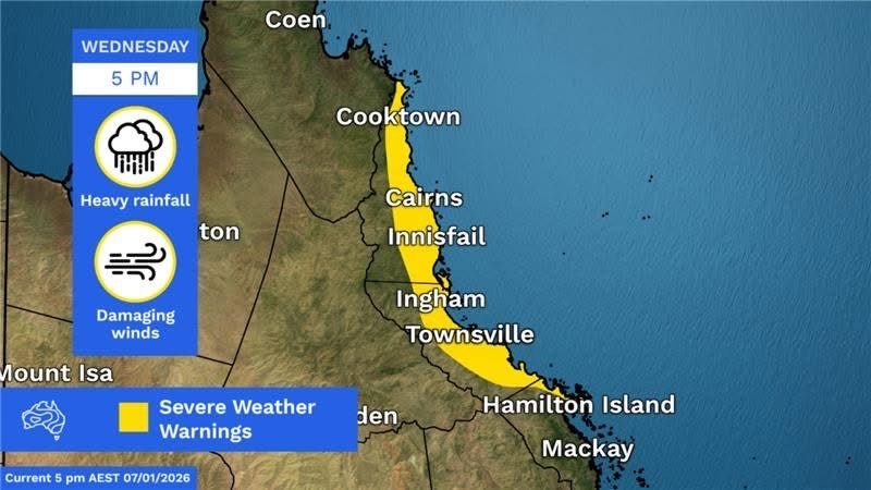
Cook Shire is ensuring it is ready for the worst following severe weather warnings for the area. Photo: Bureau of Meteorology.
Cook Shire residents are bracing themselves for a potential cyclone and more flooding as heavy rain persists across Far North Queensland.
The Bureau of Meteorology (BOM) issued severe weather warnings as a tropical low, known as 12U, developed off the coast over the Coral Sea.
Cook Shire Council has placed resilience hubs and local area community response officers (LACROs) on standby, ensuring residents have the support they need should freak weather occur.
“While the system is currently looking fairly benign, these lows can be unpredictable, so it’s important to stay aware and keep an eye on forecasts,” Acting Mayor Gavin Dear said.
“We’ve learnt a lot since Jasper, with new local resilience hubs, stronger communications and response agencies better prepared.
“If it passes us by, great — but if it doesn’t, we’re in a much stronger position than we were two years ago.”
Resilience hubs, which are familiar facilities across the shire’s communities, can be activated during extreme weather to provide shelter and community support, as well as access to reliable information.
Each hub will be supported by trained LACROs, who will serve as the primary point of contact for direct communication between residents and the council.
All hubs have been prepared with Starlink internet connectivity to maintain communication during outages, and all except Coen are equipped with backup generators.
Council advised that emergency service agencies are also positioning additional resources across the region and are ready to respond if needed.
The BOM reported that 12U had a 25 to 35 per cent chance of developing into a tropical cyclone, with the system forecast to bring another burst of heavy rainfall to the region.
“We are likely to see monsoonal rain and heavy falls re-emerging for the north-east tropical coast as our tropical low pressure system, 12U, brings in more moisture towards the coast,” senior meteorologist Miriam Bradbury said on Wednesday (7 January).
“We’re expecting fairly scattered showers and storms across much of Far Northern Queensland, but that stretch of coast between Townsville up to around Cooktown is likely to see the heaviest falls.”
The BOM also issued a severe weather warning for damaging winds across the north-west of Cape York and the Torres Strait Islands on Thursday, with wind averaging 55 to 65 km/h and peak gusts of 90 km/h expected to persist through the weekend.
Resilience hubs on standby
- Helenvale – Rossville Retreat
LACROs: Dave and Sandy Bates - Rossville – Rossville Hall
LACRO: Pasha Lynch - Bloomfield – Ayton Library and Tin Shed
LACRO: Suzie Auld - Lakeland – Lakeland Library
LACRO: Alan Wilson - Coen – JS Love Hall
LACRO: Taylor Wright - Portland Roads – Portland Roads Town Hall
Town Agent: Neale Dahl
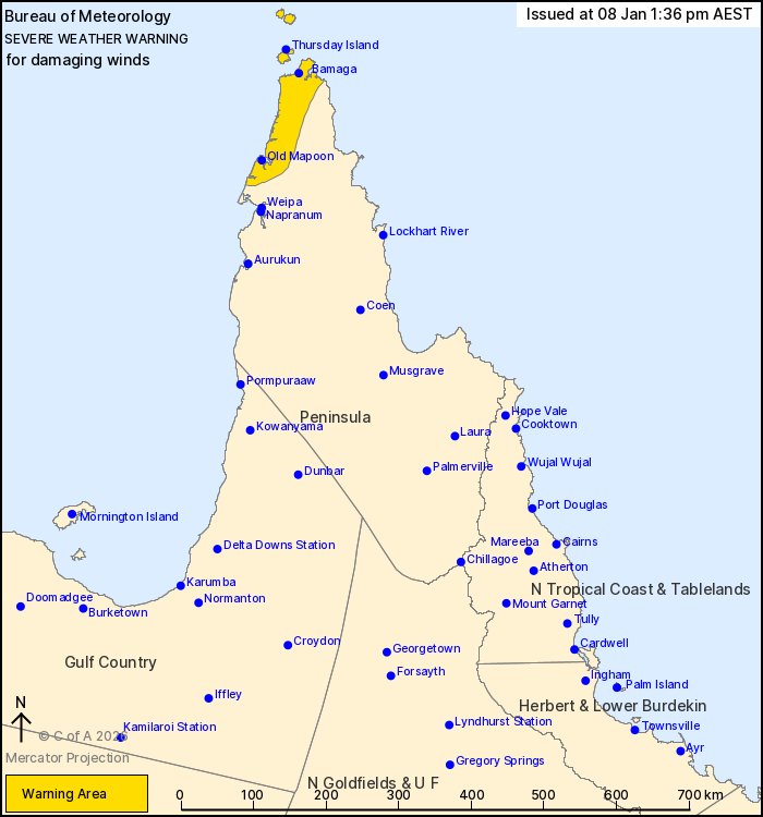
North-western Cape York and the Torres Strait are expected to experience damaging winds with peak gusts up to 90 km/h. Photo: Bureau of Meteorology.
