A satellite image of ex-tropical cyclone Maila on Sunday. Image: BoM.
Ex-tropical cyclone Maila has significantly reduced in intensity, but the remnants of the weather system will likely bring rain, thunderstorms and gusty winds to Far North Queensland in coming days.
Maila was originally forecast to cross the coast north of Cairns as a category 2 about Tuesday, according to the Bureau of Meteorology (BoM).
It follows Tropical Cyclone Narelle crossing the Cape on the morning of 20 March, whipping up 225 km/h category 4 winds and causing significant damage.
By Sunday afternoon (12 April), Maila had reduced to a tropical low.

Cairns beaches have been hammered by wild weather. Pictured is Holloways Beach’s lifesaver hut after TC Narelle. Photo: Luke Mortimer.
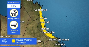
“Tuesday will see the remnants of ex-tropical cyclone Maila and a surface trough approach the Far North Queensland coast, causing showers, rain areas and isolated thunderstorms to develop across northern Queensland, with isolated heavy falls possible,” the BoM states.
“Wednesday will see rain and thunderstorm activity spread west and south across much of northern Queensland, with locally moderate to heavy falls possible.”
Showers and storms are likely to continue into Thursday and Friday.
Original Article published by Luke Mortimer on Region Tropical North Queensland.