The aftermath of a flooding event in December 2023. Photo: File.
While ex-Tropical Cyclone slowly moves inland, the Bureau of Meteorology (BOM) is cautioning southern Cape residents to remain vigilant for heavy rainfall today (13 January 2025).
Over the weekend, a tropical low known as 12U developed into a category two cyclone on 10 January before downgrading into a category one cyclone overnight.
The cyclone, which was originally forecast to make landfall between Cooktown and Cairns, moved south, crossing the coast between Ayr and Bowen.
However, BOM meteorologist Christie Johnson said they were starting to see it moving in a northwesterly direction.
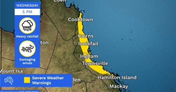
“We’re expecting it to move towards the southern end of the Cape York Peninsula on Tuesday, and then linger around the Gulf country on Wednesday,” she said yesterday.
“We could see over southern areas the chance of some heavy rainfall that could lead to flash flooding.
“It’s generally over the inland parts of Cape York, probably south of Cooktown to Kowanyama. There is still a risk of thunderstorms further north than that, they’re a bit less likely to produce that heavy rainfall that could lead to flash flooding.”
Ms Johnson said, by Wednesday, Cape York should see the severe weather ease up into usual wet season showers.
“As we go into the rest of the week and the weekend, we’re going to continue to see the monsoon trough lingering in the area,” she said.
“It’s probably just going to be normal showers and thunderstorms through Thursday and Friday at this stage.
“There may be a little bit of an increase in moisture on the weekend as we see that monsoon surge increase a little bit, but the biggest day of risk of particularly heavy thunderstorms is going to be on Tuesday.”